|
epix
|
cfQue 1620
|
TracPak
|
Maps
|
Accessories
|
Buyer's Guide
| Shopping basket |
| GARMIN eTrex H |
|
All items are available while supply lasts. If you have questions, please use our contact form. |
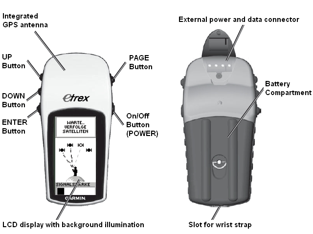
Hand held GPS receiver with high-sensitive MediaTech antenna, large display and serial interface.
The GARMIN eTrex H is very easy to use, supports multiple languages and has an extremely sensitive antenna, which provides navigation information outdoors, in a car, in a train or even in an airplane (see MapSource examples). The built-in serial interface supports data exchange with a PC.
Comparison of the models of the eTrex H series:
All models provide similar functions; these are the main differences:
| Feature / Model | eTrex H | Venture HC | Summit HC | Legend HCx | Vista HCx |
|---|---|---|---|---|---|
| Interface to PC | serial | USB | USB | USB | USB |
| Shows map | - | YES | YES | YES | YES |
| Electronic compass, barometrical altimeter | - | - | YES | - | YES |
| Slot for µSD memory card | - | - | - | YES | YES |
| Automatic route calculation | - | - | - | YES | YES |
| Price | discontinued | discontinued | discontinued | discontinued | discontinued |
Contents: Features - Overview - Main Pages - Price - Options - Downloads - Order
 |
Features:
¹) TTFF: Time To First Fix, time until the first information about the local position is acquired. Information for navigation:
|
| To table of contents |
GARMIN eTrex H overview:
| To table of contents |
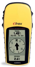
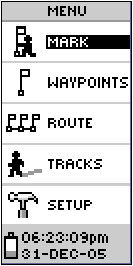
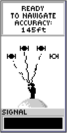
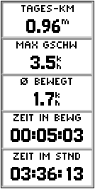
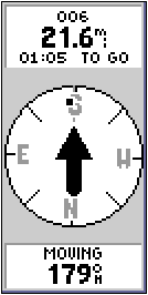
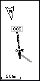
Main pages of the GARMIN eTrex H:
Note: The images below show the display of the eTrex H. Many of the pages are configurable, the pictures are just examples. For the data fields, there is a choice of 31 different values, see selection.
| Main menu | Satellites | Trip Computer | Pointer | Map |
 |
 |
 |
 |
 |
|
|
For each data field, you can choose from 31 different values.1) |
|
|
Data fields on pages with user selectable data fields:
- For each data field, you can choose one from the following 31 values.
- You can configure the device to show values in english or metric units.
| No | Name | Explanation |
|---|---|---|
| 1 | Bearing | The compass direction from a position to a destination measured to the nearest degree; also called an azimuth. In a GPS receiver, bearing usually refers to the direction to a waypoint. |
| 2 | Course | The direction from the beginning landmark of a course to its destination (measured in degrees, radians, or mils) or the direction from a route waypoint to the next waypoint in the route segment. |
| 3 | Distance to next | Current distance to the next waypoint or turn. |
| 4 | Distance to destination | Current distance to the final destination. |
| 5 | ETA at next | Estimated arrival time at the next turn. |
| 6 | ETA at destination | Estimated arrival time at the final destination. |
| 7 | Elevation | Current altitude above sea level. |
| 8 | Heading | The direction in which you are currently moving. |
| 9 | Latitude / Longitude | Coordinates of the current position in standard format |
| 10 | Location | Coordinates of the current position in user specific format |
| 11 | Odometer | Total distance travelled since last reset*). |
| 12 | Off Course | The distance you are off the desired course. |
| 13 | Speed | Current speed. |
| 14 | Speed - Maximum | Maximum speed since last reset*). |
| 15 | Speed - Moving Avg. | Average speed without the time with no motion since the last reset*). |
| 16 | Speed - Overall Avg. | Average speed including the time with no motion since the last reset*). |
| 17 | Sunrise | Time of sunrise at the current position. |
| 18 | Sunset | Time of sunset at the current position. |
| 19 | Time To Destination | Estimated travel time to the final destination. |
| 20 | Time To Next | Estimated travel time to the next waypoint (turn, crossing etc.). |
| 21 | Time of Day | Current time. |
| 22 | To Course | Direction to the planned course. |
| 23 | Trip Odometer | Travelled distance since last reset*). |
| 24 | Trip Time - Moving | Time with motion since last reset*). |
| 25 | Trip Time - Stopped | Time without motion since last reset*). |
| 26 | Trip Time - Total | Total time since last reset*). |
| 27 | Turn | The direction of and the distance to the next turn on a route. |
| 28 | Velocity Made Good | The rate of closure to the destination, based upon your current speed and course. |
| 29 | Vertical Speed | Current ascending or descending speed. |
| 30 | Waypoint At Dest | Name of the waypoint at the final destination. |
| 31 | Waypoint At Next | Name of the next waypoint. |
*) You may reset the trip-counters, the Odometer and the Maximum Speed separately.
| To table of contents |
Price:
This model has been discontinued; however, you can still order options for the eTrex H.
| To table of contents |
Options:
| Power cord for car cigarette lighter | CHF 33 | [Picture and details] | ||
| NMEA/RTCM data cable without power connection | CHF 14 | [Picture and details] | ||
| Protective case | CHF 15 | [Picture and details] | ||
| Belt clip | CHF 20 | [Picture and details] | ||
| Retractable lanyard | CHF 30 | [Picture and details] | ||
| Mounting adapter for larger handlebars (25..32 mm) | CHF 12 | [Picture and details] | ||
| Mounting kit for dashboard | CHF 23 | [Picture and details] | ||
| Adhesive base for dashboard mounting kit to use it in a second vehicle | CHF 12 | [Picture and details] |
All options for the GARMIN eTrex H in detail.
| To table of contents |
Downloads:
Here we provide additional documentation and software updates related to the eTrex H.
- Owners manual: (as PDF document)
- Quick reference guide: (as PDF document)
- Firmware Upgrade V3.40 (Self-extracting ZIP-file, requires a PC and a connection cable, 824 kB)
- List of changes made with Firmware Upgrades
| If Adobe Acrobat Reader is not installed on your computer, you may download and install it for free. |
| To table of contents |
Order:
To order options for the GARMIN eTrex H please:
- Click on the price or the shopping basket symbol
 to add the item you wish to purchase to the shopping basket. Your browser must accept cookies, otherwise the shopping basket won't work.
 - If the shopping basket does not work, please use this form.
Please read our terms and conditions.
| To table of contents |
Specifications and packaging of the products are subject to change without notice.
|
|
TRAMsoft GmbH Breitlenstrasse 8 / 8634 Hombrechtikon / Switzerland Contact Last modification: 08/26/2025 (RA) (This document was created with TRAMsoft XbCMS V1.3-00, does not require any browser specific features and is compliant with the W3C standard "HTML 4.01 Transitional") |
|